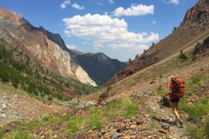
*In efforts to keep our backpacks as light as possible, the photos during this trip were taken using only the iPhone 6S.
Pulling up to Convict Lake was like arriving to a long-awaited party for adventurers. For months prior, I’d heard so much about this beautiful stretch of mountainous trail in the backcountry of the Eastern Sierra Nevadas from my husband, Richie and my brother, Devin. They had attempted this hike back in November to which they ultimately had to concede when the blustery winter weather patterns started to roll in. Ever since, they’ve promised revenge on the mountain that once defeated them.
Somewhere in the mix of all the discussions for round two, I seemed to have committed myself to joining the expedition, not fully aware of what I was signing myself up for…not that it would have really mattered. Admittedly, I am an adventure feign and when an opportunity arises to test my strength and endurance, I go for it. As someone who not only loves hiking regularly, but also did track and cross-country growing up, this would be a great evaluation of just how fit I really am (or am not!).

The elevation gain from Convict Lake to our furthest point was going to be an intense uphill battle. Altitude sickness is a real possibility at heights like that, even around Convict Lake, our starting point. In order to give ourselves time to adjust to the change in altitude and start our trek refreshed, we decided to camp in the Convict Lake campground the night before and acclimate. I would recommend the same for anyone else coming in from outside the immediate area so you aren’t cramming too much into your first day. It’s also a nice transitionary spot to be in-between city living and the upcoming days of pure wilderness.  The trail is not exactly obvious in some parts. Even with maps, we learned the hard way that you must pay scrupulous attention to the path, or you will loose it.

The hike begins here, Convict Lake, but if you didn’t know any better, you might assume it was Jurassic Park. Waking up to a view this enchanting was all the motivation I needed to get the day going. The water was pristine despite being a popular destination and provides a gorgeous backdrop for the first 1.5 miles of the hike. 
Fast forward a couple of hours and you’ll find yourself at the old bridge river crossing. We had talked to another couple who were coming back down the mountain and mistook their advice of “not waiting to cross the water” and “to do it as soon as you can”. Unfortunately that led us to cross at the very first sign of water (way too early) and we lost the trail for a solid 1.5-2 hours of exhaustive searching. It led us to some magnificent views of the valley but also some terrifying scree slides that eventually gave us sight of the correct trail, all the way across the valley on the opposite mountain. 
Once we finally corrected our course, we arrived at the remains of the old bridge. It got washed out during the 2012 floods, along with bits of the trail, making it inaccessible for hikers to use. Although the photos don’t do justice to the culmination of the rushing river and mighty waterfall, the white caps on the surface of the rapids give a little insight to just how powerful the flow was. Rumor had it that other experienced hikers had turned back at the notion of crossing such dangerous torrents merely weeks before us. What you don’t see in these photos is the long, forbidding way down, should the water sweep you off your feet. One would have to be miraculously lucky to survive such a fall.
With the assistance of my handy walking sticks and trusty water shoes, I was able to cross both streams successfully. The frigid temperatures shocked my system, giving me a much needed second wind to continue the trek.

Crossing the river was a gratifying milestone. Most day hikers turn around before or at this point to avoid the hassle of it all and spare themselves the laborious task of climbing another 1,000 ft in elevation gain over the next 1.5 miles.

For us, this was the stretch of trail that tested us the most. The views were out of this world but the actual trail was extremely narrow with fatal cliffside drop offs and steep inclines. I felt so tiny and vulnerable out there on this magnificent mountain. Whoever pioneered it to pave the way for others to pass though has earned an incredible amount of respect in my book.  That last 1.5 miles to Mildred Lake was no joke. Once the sun dipped over the mountain, we began to loose light rather quickly. With no real gauge on how much longer the trail was, or where we could even camp out, the uncertainty of it put a little more spunk in our step. As the last bits of daylight slipped away from us, we triumphantly reached Mildred Lake. We immediately got to work on setting up camp for the night and finished without a spare moment.

In the morning, I arose to the sounds of a gushing waterfall and the sight of snowy peaks in the near distance. It’s hard to believe there could still be so much snow packed onto the mountain in the middle of summer. The balmy weather made for a pleasant breakfast climate before we headed out for our next leg of the trip. Believe it or not, there is a nearly invisible pathway just above where I’m pointing that leads up to Lake Dorothy and Lake Genevieve. 


And so the journey continued, around Mildred Lake and up into the next perilous scree slide of a mountain. 
After about 2 hours of uphill cardio we reached a fork in the road. Lake Dorothy is known the be the largest lake in the area, and also one of the most beautiful, but we were determined to push ourselves just a wee-bit further to Lake Genevieve.

Lake Genevieve was a sight for sore eyes. How exciting the glimpse of yet another stunning body of water was. When you rely on the presence of such to keep you hydrated, it adds so much more to its appeal. By this time we were sweaty and eager to stake out a spot to call home for the next two days, but first, we had to work our way down to it. 
Needless to say, we were always famished and ready for any course meal. We had spent weeks dehydrating fruits, veggies, eggs, oatmeal and dinners like spaghetti, chili and lentil stew. We most certainly did not eat poorly. 
Lake Genevieve was the perfect lake to set up camp for a few days. As the only occupiers of the lake, we secured a great spot amongst the pine trees and spent the afternoon basking in the sun and trying to catch some brook trout (with no luck). The water was a tad too cold to go for a real swim but it was nice to freshen up in after such a long journey.
 Although our initial plans were to reach the summit of Cloverleaf Lake by way of day hike from our Lake Genevieve camp, I woke up with an awfully painful sore throat. The drop in temperature at night was no match for my flimsy pajamas and I was forced to pay the price. Earlier that morning, Devin had gone on an unintended walk up to Lake Edith, just before Cloverleaf, and returned with a case of mosquito bites so bad, it looked as though he was re-experiencing chicken pox. Given the circumstances at hand, we all thought it was best to take the rest of the day off to relax and recuperate before the big hike back.
Unfortunately, I fell even more ill throughout the day and retired to my tent for the remainder of the it. The timing could not have been worse to fall victim to a head cold. My eyes ached, my nose was dripping uncontrollably and no amount of hot tea could soothe my swollen throat. I’ve never related to the expression, “I want my mommy” more. Just the thought of having to hike all the way back down to the car whilst feeling this way was an overwhelming thought. Things like tissue paper and Advil became highly coveted luxury items to me.

It was my utter lack of choice and pure willpower that got me out of “bed” on our last day. I’m not going to lie…I cried. Once that was over, I put on my big girl pants, packed up my shit and continued to put one foot in front of the other. Even though I felt crappy, there was no way I couldn’t at least stop by Lake Dorothy for a moment to take a good, hard look at it. I can see why people refer to it as the most beautiful lake up there. Can’t you?

Back at the top of Lake Mildred, we stopped for a short break before heading down the scree path. Richie descended first so we could get a reverse perspective of this part of the “trail” because it’s hard to really grasp how absurd it is otherwise.

I had to highlight where I am in the photo or it would be nearly impossible to spot me. It may not seem high or steep, but it most definitely was. Each step sounded like I was walking across mounds of broken ceramic plates. Careful foot placement became the name of the game because one unsecured rock could mean major injuries. 

Most of the trail back was downhill, however, it did not make it any less unnerving. I must’ve thanked the heavens a hundred times for my walking sticks. They really helped to lessen the effects of gravity and allowed me to keep balance in the most precarious spots. 
Finally, after 4 and a half hours of hiking down the valley, we laid our eyes upon Convict Lake once again. Those last two miles felt like 20 as we pushed ourselves to the finish line. A handful of day hikers stopped to ask us for any helpful tips we could offer and they all seemed quite amazed that we had come so far. For as long as I can remember, I had always been that day hiker in awe of the “hardcore” backpackers, but now, that crazy backpacker was me.
The journey was difficult, and even felt outrageous at times, but it also gave me so much pride, gratitude and respect for mother nature as well as myself. I now realize the distinct similarities between life and climbing a mountain, the most obvious fact being that reaching a goal is no different than reaching your summit. You must focus on the task at hand, you mustn’t be afraid to take risks, and if you continue to press onwards, you will inevitably reach your goal. And this is what these expeditions are all about: living and learning.
I’m more than pleased with the way the hike turned out and even more thrilled with how I overcame my fears, my feelings, and perceived inadequacies. It’s an achievement earned by few but respected by many, and those are the most satisfying goals to reach. 🙂


